Long Cove Point Association
Cove History
Native to the Long Cove area were the Etchemins of mid-coast Maine who were also part of the larger Wabenaki tribe. These people lived in the area from the St. John River to the Kennebec.
Those who lived in Pemaquid before the Europeans arrived were hunter-gatherers and fisherfolk. Their permanent settlement of wigwams was somewhere in Pemaquid Harbor, but they were nomadic at times when hunting took them inland.
When at the coast, they gathered oysters, clams, and berries, used fish weirs, perhaps in Long Cove itself, and trolled from dugout canoes for bass, salmon, and even swordfish and whales
Panoramic View of Long Cove in the 1920s
(Based on information in John Neff's A Witness to History: The Story of Long Cove, 1996). A second edition of Mr. Neff’s book was released in Nov. 2021. Additional information can be found by clicking here.


From 1482 on, men sailed from Bristol, England and elsewhere to the area that became Bristol, Maine, including John Cabot (1497), Sebastian Cabot (1509), and Martin Pring (1603 & 1606).
In 1605, Captain George Waymouth landed at Monhegan and began trading with natives on the mainland, coming even to New Harbor where there was a footpath to the settlement at Pemaquid Harbor. Suspecting a conspiracy, the English took five natives hostage whom they first took to England and then brought back to Pemaquid two years later.
In 1614 John Smith fished from Monhegan and charted the coast which he called New England. When Samoset arrived in Plymouth in 1620 to greet the newly arrived pilgrims, Governor Bradford wrote that he had learned English by speaking with fishermen on Monhegan.
Samoset?

In June 1623, Dixie Bull was trading for furs in Penobscott Bay, Maine, when a roving company of French pirates seized all of his provisions, leaving him destitute. He persuaded other fishermen, traders and seamen to join him in plundering trading vessels and attacking trading posts along the New England coast - thus becoming New England's first pirate. The authorities sent five vessels on an expedition against Bull, but he was nowhere to be found.
Bull stole provisions from the fort and storehouse at Pemaquid in 1632, escaping eastward toward Muscongus Bay. He disappeared from the New England area in 1633, perhaps joining the French or perhaps returning to England. According to a popular poem of the 1600's, Dixie Bull was killed in a sword fight.

Shell Midden Mounds
Fort William Henry, built in 1692
Earlier forts here date from 1607.

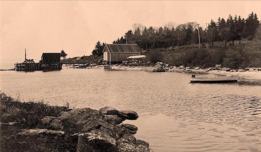
View of Long Cove from Salt Pond
John Pierce of London received a grant of 100 acres in Pemaquid from the Council of Plymouth, England in 1621. He attempted to establish colonies but failed.
In 1626 Robert Aldsworth and Gyles Eldridge purchased Monhegan from Abraham Jennings of Plymouth Plantation and in 1631 received the Pemaquid Grant of some 12,000 acres that included Long Cove.
During this period the native population declined, and European commercial fishing increased.
There may have been a fort in New Harbor, and there is a reference to a barge attack on the harbor during the War of 1812.
In the 17th century relations with the natives became increasingly poor with the taking of lands and the introduction of foreign diseases and alcohol to the population.
The English claimed large tracts of land in the Pemaquid area also claimed by the French, and the disputes were to continue for 100 years. In 1668 Massachusetts claimed the Province of Maine, a claim that lasted until statehood in 1820.

The dirt road that became Route 32

Maurice Day Map of 1934
The first house built in the area is said to be the Will Carter house of about 1645 now owned by the Grams. The living was precarious, however, and "as late as 1742 the residents...would now and again sail to New Harbor and walk over to the fort in times of special danger." (Neff, p. 33)
After hostilities ceased with the natives and a treaty was signed in 1763, the French relinquished their claims and settlement of the area increased.
During the War of 1812, there was a British blockade and patroling along the coast. In 1813 some fishermen were captured and left on Damariscove Island. In response some locals armed a sloop called the Increase which threatened the British ship, the Crown, off Long Cove Point and the Brits surrendered. A second encounter in the same area that fall between the British Boxer and the USS Enterprise also ended in the locals' victory, though at the cost of the lives of both captains.
The land at Long Cove Point was inherited by Benjamin Tukey in 1815, and was used as pasture for sheep and a dairy herd. Up the hill from the Cove was farmland.
More settlements ensued, including the "Homestead" (now Wales) at the head of the cove built by a member of the Tukey family in about 1830. Those who lived in Long Cove worked the land and supplemented their income with fishing. Some young men joined the Union Army during the Civil War. Following the war, more villages sprang up.
In 1896 a surveyor named Chamberlain placed markers for 64 lots for cottages, most selling for $10 to $25 each. In the next decade about 16 cottages were built.
Some cottages have been in the same family since they were built including Tukey (1878), Charland (1917), and Hendry (1931).
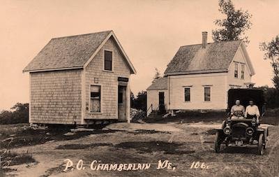
The old Chamberlain Post Office
The Post Office was first built in 1905 with Minnie Tukey as postmistress, and was named after Henry Chamberlain of Round Pond who had owned Damariscove Island.
In 1920 or 1921, four men (Ralph Files, Harry Brown, Arthur Heald and Walton Hendry) formed a company and bought the Hackleton farm, both for their own use and for development. The brochure extols "The Land of Treasured Vacations" as the most beautiful spot on the Atlantic north of Rio. (See complete brochure at left.)
In 1922 Camp Chequers was built (now Farrin). In 1925 electricity came to the cove, and finally in the 1970s cottages were required to treat their own sewage instead of dumping it into the cove.
During WWII many cottages remained empty because of gas rationing and because many young people were involved in the war. Residents in the area organized to patrol the coastline and everyone on the coast had to observe blackouts at night.There were great celebrations at the end of hostilities in August of 1945.
In the late 1920s a wharf (now gone)was built on the east side of the cove, and in 1983 25 families organized a private association to build and maintain a dock and float that still exist today on land later deeded to the Long Cove Dock Association by Roger Fessaguet, a long-time resident of the point.

Brochure of ca. 1925
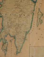
Hopkins Lincoln County Map,1857

View of Camp Chequers from the cove:
The pier was built by Scott Carter in the 1890s and the boathouse built later (apparently sometime before 1920) by his son Will Carter.
It was a "working" pier, as opposed to the recreational pier built on the east side of the cove for Robert Guyot around 1930.